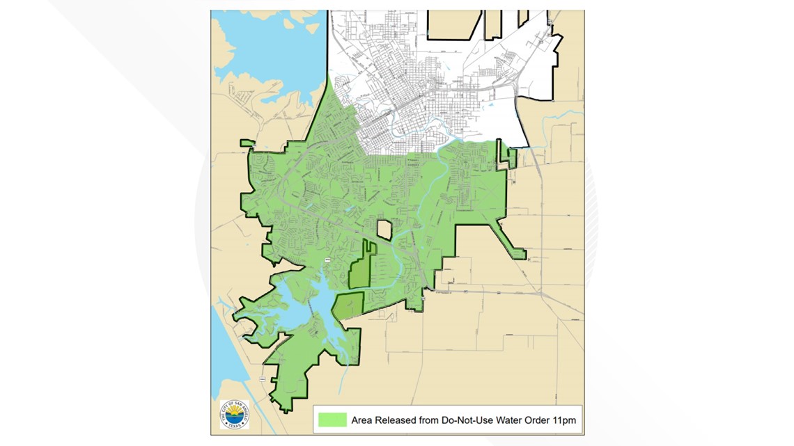
SAN ANGELO, Texas — UPDATE: The City of San Angelo and the Texas Commission on Environmental Quality have approved a new area to be released from the "do-not-use" water advisory.
Areas included in the high plane released from the do-not-use order:
- West of Howard St. from Glenna St. to Junius St.
- South of Junius St. from Howard St. to N. Van Buren St.
- West of N. Van Buren St. from Junius St. to Webster St.
- South of Webster St. from Junius St. to N. Harrison St.
- West of Harrison St. from Webster St. to Houston Harte Frontage Road
- West of Westland Ave. from Houston Harte Frontage Road to Sherwood Way
- West of N. Fillmore St. and S. Fillmore St. from Sherwood Way to Avenue J
- South of W. Avenue J from S. Fillmore St. to S. Koenigheim St.
- East of S. Koenigheim St. from W. Avenue J to W. Avenue I
- South of W. Avenue I and E. Avenue I from S. Koenigheim St. to South Concho River
- South of South Concho River and Concho River from E. Avenue I to the City Limits at S. Loop 306 Frontage Rd.
Wholesale customers that are also released from the do-not-use order:
- Concho Rural Water Grape Creek
- Twin Buttes Water System
- Concho Rural Water Pecan Creek
- Goodfellow AFB
- MillersviewDoole Water System


ORIGINAL STORY: Some areas in San Angelo have been taken off the "do-not-use" water order, according to City officials at a press conference Tuesday afternoon.
San Angelo residents affected by the advisory, who are in need of water, can soon receive it from the City. City Manager Daniel Valenzuela said at least 10 semi-trucks loaded with water will be available at the Foster Communications Coliseum, 50 E. 43rd St., possibly by Tuesday evening.
On Monday, the City of San Angelo issued the advisory across the City and for all customers within the City water utility system after investigating foul-smelling water samples from the PaulAnn area.
The samples were expedited to an Austin lab to determine the cause of the odor.
The Water Department and City leadership have been working through Monday and into Tuesday on this issue with engineering and legal consultants from Austin and Abilene, as well as with the Texas Commission on Environmental Quality and the Lower Colorado River Authority to resolve any public health concerns quickly.
In the release, the City said it "would like to assure everyone that we have this under control. As of now, we will be lifting restrictions in the area that we refer to as the high plane"
Water storage and water distribution both play an important role in a water system functioning properly. Water distribution lines are used to transport drinkable water to service connections.
The City of San Angelo operates two pressure planes because of the difference of elevation throughout the City. Each pressure plane serves portions of the distribution system that are hydraulically separated from other pump stations or pressure planes.
The hydraulic separation was in existence and in operation prior to the do-not-use order, which has allowed the City and TCEQ to determine that the apparent contamination has been limited to a portion of the lower pressure plane.
Because the apparent contamination appears to be limited to a portion of the lower plane, the TCEQ and City have determined that the water in the upper pressure plane is safe to begin using again and that portion of the City is released from the do-not-use order.
As of Tuesday afternoon, the contaminate in San Angelo water is still unknown.
The City said it is continuing to work with the TCEQ to lift restrictions on more of the City, but the timeliness is dependent on the LCRA labs and TCEQ administrators.
The test results are now expected sometime Wednesday, Feb. 9.
"We know that this is an inconvenience for everyone, but the health and safety of our citizens is our top priority right now. We are doing everything we can to restore clean, safe water to this community," the release said.
Areas included in the high plane released from the do-not-use order:
- Twin Buttes Water System
- Concho Rural Water Grape Creek
- West of Howard St. from Glenna St. to Junius St.
- South of Junius St. from Howard St. to N. Van Buren St.
- West of N. Van Buren St. from Junius St. to Webster St.
- South of Webster St. from Junius St. to N. Harrison St.
- West of Harrison St. from Webster St. to Houston Harte Frontage Road
- West of Westland Ave. from Houston Harte Frontage Road to Sherwood Way
- West of N. Fillmore St. from Sherwood Way to Vanderventer Ave. and Dena Dr.
- West of Phil George Dr. from Dena Dr. to University Ave.
- North of University Ave. from Phil George Dr. to S. Johnson St.
- East of S. Johnson St. from University Ave. to Oxford Ave.
- North of Oxford Ave. from S. Johnson St. to Sherwood Way
- North of Sherwood Way from Oxford Ave. to Westwood Dr.
- East of Westwood Dr. from Sherwood Way to Robin Hood Trail
- North of Robin Hood Trail from Westwood Dr. to Southwest Blvd.
- West of Southwest Blvd. from Robin Hood Trail extension (imaginary line) to Sherwood Way
- North of Sherwood Way from Southwest Blvd. to FM2288/Southland Blvd.
- West of Southland Blvd. from Sherwood Way to Green Meadow Dr.
- South of Green Meadow Dr. from Southland Blvd. to Oak Grove Blvd.
- East of Oak Grove Blvd. from Green Meadow Dr. to W. Loop 306
- South of W. Loop 306 from Red Arroyo (west of Oak Grove Blvd.) to S. College Hills Blvd.
- West of S. College Hills Blvd. from W. Loop 306 to Canyon Creek Dr.
- South of Canyon Creek Dr. from S. College Hills Blvd. to Fall Creek Dr.
- East of Fall Creek Dr. from Canyon Creek Dr. to W. Loop 306
- South of W. Loop 306 from Fall Creek Dr. to Buckskin Dr. (separation from Bentwood Area to properties to the east, including Butler Farm)
- West of Buckskin Dr. and imaginary line to Country Club Rd.
- North of Country Club Rd. to Fish Hatchery Rd.
- South and West of Country Club Rd. from Fish Hatchery along City Limits
Wholesale customers that are also released from the do-not-use order:
- Concho Rural Water Grape Creek
- Twin Buttes Water System
The City is working with TCEQ and continuing to sample the apparent contamination area to determine the feasibility of releasing portions of the lower pressure plane from the current do-not-use order. Those efforts are ongoing.
Additional information will be following as it becomes available.
View the attached map for more information.

